GEN 3.2 Aeronautical chaRTS
3.2.1 RESPONSIBLE SERVICES
3.2.2 Maintenance of charts
3.2.3 Purchase arrangements
Air Navigation Services of the CR
AIM Centre
Navigační 787
252 61 Jenec
3.2.4 Aeronautical chart series available
Aeronautical Chart − ICAO 1:500 000;
Aerodrome Chart − ICAO;
Aircraft Parking/Docking Chart − ICAO;
Parking Stands and Taxiing on Apron
Aerodrome Obstacle Chart − ICAO − Type A;
Precision Approach Terrain Chart − ICAO;
Enroute Chart − ICAO;
FRA chart;
SEE FRA chart;
SEE FRA, BALTIC FRA a SECSI FRA chart;
Standard Departure Chart − Instrument (SID) − ICAO;
Standard Arrival Chart − Instrument (STAR) − ICAO;
Instrument Approach Chart − ICAO;
VFR Arrivals and Departures Chart;
ATC Surveillance Minimum Altitude Chart;
Circling Approach Chart;
Bird Hazard Concentration Areas;
The charts currently available are listed under GEN 3.2 para 5 of this subsection.
3.2.4.2 General description of each series
-
Aeronautical Chart − ICAO 1:500 000
This series is constructed on Lambert Conical. The aeronautical data shown have been kept to a minimum, consistent with the use of the chart for visual air navigation. It includes a selection of aerodromes, significant obstacles, elements of the ATS system, prohibited, restricted and danger areas, and radio navigation aids. The chart provides information to satisfy visual air navigation and is also used as a pre−flight planning chart.
-
Aerodrome Chart − ICAO
This chart contains detailed aerodrome/heliport data to provide flight crews with information that will facilitate the ground movement of aircraft:
-
from the aircraft stand to the runway; and
-
from the runway to the aircraft stand.
The chart also provides additional operational data about the aerodrome.
-
-
Aircraft Parking/Docking Chart − ICAO
This chart is produced for those aerodromes where, due to congestion of information, details necessary for the ground movement of aircraft along the taxiways to and from the aircraft stands and for the parking/docking of aircraft cannot be shown with sufficient clarity on the Aerodrome/Heliport Chart − ICAO.
-
Parking Stands and Taxiing on Apron
This chart is produced for those aerodromes where, due to congestion of information, details necessary for the ground movement of aircraft on apron to and from the aircraft stands and for the parking/docking of aircraft cannot be shown with sufficient clarity on the Aerodrome/Heliport Chart − ICAO.
-
Aerodrome Obstacle Chart − ICAO − Type A (operating limitations)
This chart contains detailed information on obstacles in the take−off flight path areas of aerodromes. It is shown in plan and profile view.
-
Precision Approach Terrain Chart − ICAO
This chart provides detailed terrain profile information within a defined portion of the final approach by the use of radio altimeters. This chart is produced for all precision approach Cat II and III runways.
-
Enroute Chart − ICAO
This chart contains all aerodromes, prohibited, restricted, danger, temporary segregated and temporary reserved areas and the air traffic services system. The chart provides the flight crew with information that will facilitate navigation along ATS routes in compliance with air traffic services procedures.
-
FRA chart
The charts are published for free route airspace in the Czech Republic, vertically limited from FL 95 to FL 660. The charts contain information for flights carried out along a preferred trajectory using FRA significant points instead of using conventional ATS routes. The charts contain FRA significant points, area of FRA aplication including the cross-border SEE FRA, prohibited, restricted, danger, temporary segregated, temporary reserved areas, non – standard planning zones and the air traffic services system.
-
SEE FRA chart
This chart displays horizontal confines of the cross-border SEE FRA and its vertical limits.
-
SEE FRA, BALTIC FRA a SECSI FRA chart
This chart displays horizontal confines of SEE FRA, BALTIC FRA, SECSI FRA and cross-border FRA operations between the relevant FRAs.
-
Standard Departure Chart − Instrument (SID) − ICAO
This chart is produced whenever a standard departure route − instrument has been established. The aeronautical data shown include the aerodrome of departure, aerodrome(s) which affect the designated standard departure route − instrument, prohibited, restricted and danger areas and the air traffic services system. This chart provides the flight crew with information that will enable them to comply with the designated standard departure route − instrument from the take−off phase to the en−route phase.
-
Standard Arrival Chart − Instrument (STAR) − ICAO
This chart is produced whenever a standard arrival route − instrument has been established. The aeronautical data shown include the aerodrome of landing, aerodrome(s) which affect the designated standard arrival route − instrument, prohibited, restricted and danger areas and the air traffic services system. This chart provides the flight crew with information that will enable them to comply with the designated standard arrival route − instrument from the en−route phase to the approach phase.
-
Instrument Approach Chart − ICAO
This chart is produced for all aerodromes used by civil aviation where instrument approach procedures have been established. A separate Instrument Approach Chart − ICAO has been provided for each approach procedure.
The aeronautical data shown include information on aerodromes, prohibited, restricted and danger areas, radio communication facilities and navigation aids, minimum sector altitude, procedure track portrayed in plan and profile view, aerodrome operating minima, etc..
This chart provides the flight crew with information that will enable them to perform an approved instrument approach procedure to the runway of intended landing including the missed approach procedure and where applicable, associated holding patters.
-
VFR Arrivals and Departures Chart
This chart is produced for VFR operation at controlled aerodromes as published in Volume II, Section AD 2 of the AIP CR. This chart governs procedures for VFR arrivals and departures and includes following data:
-
geographic data;
-
aerodrome elevation in feet and metres;
-
ATS frequencies;
-
TMA boundary, CTR boundary and boundaries of Prohibited, Restricted and Dangerous areas;
-
location and direction of RWY (RWYs);
-
coordinates and designation of VFR waypoints;
-
holding patterns over waypoints;
-
sequences of waypoints for VFR arrivals and departures and their designation;
-
bearings, distances in NM and max. altitudes between waypoints;
-
scale in NM and km.
-
-
ATC Surveillance Minimum Altitude Chart
This supplementary chart is issued for FIR Praha and for relevant CTR, TMA, MCTR, MTMA or parts of CTA, if appropriate, and provides information that enables flight crews to monitor and cross−check altitudes assigned by a controller using an ATS surveillance system.
Chart provides altitudes ensuring height 300 m (1000 ft) above obstacles located within 5 NM from the aircraft.
Altitudes in brackets are corrected for low temperatures according to ICAO Doc 8168 and apply always from 15 NOV to 15 MAR, unless published otherwise by a NOTAM.
The time interval from MRVA low temperature corrections, as determined, is based on ICAO Standard Atmosphere and long term temperature statistics in CR.
-
Circling Approach Chart
This chart is produced for PRAHA/Ruzyně aerodrome as published in Volume II, Section AD 2 of the AIP . This chart governs procedures for circling approach and includes following data:
-
geographic data;
-
aerodrome elevation in feet and metres;
-
ATS frequencies;
-
location and direction of RWYs;
-
circling approaches according to aircraft categories;
-
OCA for circling approaches;
-
scale in NM and km.
-
-
Bird Hazard Concentration Areas
This chart is produced for aerodromes PRAHA/Ruzyně, BRNO/Tuřany, OSTRAVA/Mošnov and Karlovy Vary as published in Volume II, Section AD 2 of the AIP CR. This chart includes geographic data limited, location and direction of RWY (RWYs), prevailing passages of birds and scale in metres.
3.2.5 List of aeronautical charts available
The prices of the charts are published by AIC.
| Title of series | Scale |
Name |
|---|---|---|
| 1 | 2 | 3 |
|
Aeronautical Chart − ICAO 1:500 000 | 1:500 000 | PRAHA (2231 − ABCD) |
|
Enroute Chart − ICAO | 1:1 200 000 | En−route chart (GND − FL 95) |
|
FRA chart |
1:1 200 000 1:1 200 000 |
Free Route Airspace of the Czech republic (FL 245 − FL 660) |
|
SEE FRA chart |
1:9 000 000 | South East Europe Free Route Airspace |
|
SEE FRA, BALTIC FRA, SECSI FRA chart |
N/A |
SEE FRA, BALTIC FRA, SECSI FRA |
|
Prohibited, restricted, temporary reserved, temporary segregated and dangerous areas index chart | 1:1 300 000 | |
|
Index chart of temporary reserved areas designated for operations of general aviation (TRA GA) | 1:1 300 000 | |
|
Radio facility chart | ||
|
Aerodrome Index − Chart | ||
|
Aerodrome Chart − ICAO |
1:10 000
1:12 000
1:10 000 1:10 000 1:10 000 1:15 000
1:12 000
1:12 000 1:10 000 1:20 000 |
BRNO/Tuřany BRNO/Tuřany − Markings on manoeuvring area BRNO/Tuřany − Taxi routes for critical aircraft types Čáslav Čáslav − Markings on manoeuvring area České Budějovice Karlovy Vary Kbely Kunovice Kunovice − Markings on manoeuvring area Náměšť Náměšť − Markings on manoeuvring area Náměšť − Reduced Runway Separation for Helicopters Náměšť − Taxi routes for critical aircraft types OSTRAVA/Mošnov OSTRAVA/Mošnov − Markings on manoeuvring area |
|
Aerodrome Chart − ICAO |
1:15 000
1:15 000
1:10 000 |
Pardubice Pardubice − Taxi routes for critical aircraft types PRAHA/Ruzyně PRAHA/Ruzyně − Markings on manoeuvring area PRAHA/Ruzyně − Taxi routes for A340−600, A350-1000, A380, AN124, B747−8, B777−300/300ER, C5 PRAHA/Vodochody |
|
Aircraft Parking/Docking Chart − ICAO |
PRAHA/Ruzyně − Parking stands and taxiing on apron NORTH PRAHA/Vodochody - Parking stands and taxiing on apron WEST | |
|
Parking stands and taxiing on apron |
BRNO/Tuřany − apron MIDDLE BRNO/Tuřany − apron WEST Karlovy Vary OSTRAVA/Mošnov − CENTRAL apron OSTRAVA/Mošnov − SOUTH 3 apron Pardubice PRAHA/Ruzyně − apron SOUTH PRAHA/Ruzyně − apron EAST PRAHA/Ruzyně − apron BELL | |
|
Aerodrome Obstacle Chart − ICAO − Type A (operating limitations) |
1:15 000 1:15 000 1:15 000 1:15 000 1:10 000 |
Karlovy Vary OSTRAVA/Mošnov Pardubice PRAHA/Ruzyně − RWY 24 PRAHA/Ruzyně − RWY 30 PRAHA/Ruzyně − RWY 12 |
|
Precision Approach Terrain Chart − ICAO |
1:3000/600 1:2500/500 1:2500/500 |
OSTRAVA/Mošnov − RWY 22 PRAHA/Ruzyně − RWY 24 PRAHA/Ruzyně − RWY 30 |
|
Standard Departure Chart − Instrument (SID) − ICAO |
1:500 000 1:500 000 1:500 000 1:500 000 1:500 000 1:500 000
1:300 000 1:300 000 1:250 000 1:300 000 1:300 000 1:500 000 1:500 000 1:300 000 1:300 000 1:720 000 1:720 000 1:500 000 1:500 000 1:500 000 1:500 000 1:250 000 1:300 000 1:300 000 |
BRNO/Tuřany RWY 27 − RNAV BRNO/Tuřany RWY 09 − RNAV Čáslav RWY 31 − RNAV Čáslav RWY 13 − RNAV České Budějovice RWY 09 České Budějovice RWY 27 České Budějovice Omnidirectional departures chart Karlovy Vary RWY 29 − RNAV Karlovy Vary RWY 11 − RNAV Karlovy Vary Omnidirectional departures chart Kunovice RWY 20C − RNAV Kunovice RWY 20C − RNAV Náměšť RWY 30 Náměšť RWY 12 OSTRAVA/Mošnov RWY 22− RNAV OSTRAVA/Mošnov RWY 04− RNAV Pardubice RWY 27 − RNAV Pardubice RWY 09 − RNAV PRAHA/Ruzyně RWY 24 − RNAV PRAHA/Ruzyně RWY 30 − RNAV PRAHA/Ruzyně RWY 06 − RNAV PRAHA/Ruzyně RWY 12 − RNAV PRAHA/Ruzyně Omnidirectional and visual departures chart PRAHA/Vodochody RWY 10 PRAHA/Vodochody RWY 28 |
|
Standard Arrival Chart − Instrument (STAR) − ICAO |
1:500 000 1:500 000 1:500 000 1:500 000 1:500 000 1:300 000 1:300 000 1:500 000 1:300 000 1:500 000 1:500 000 1:300 000 1:300 000 1:720 000 |
BRNO/Tuřany RWY 27 − RNAV BRNO/Tuřany RWY 09 − RNAV Čáslav RWY 31 − RNAV Čáslav RWY 13 − RNAV České Budějovice RWY 27 Karlovy Vary RWY 29 − RNAV Karlovy Vary RWY 11 − RNAV Kbely RWY 24 − RNAV Kunovice RWY 20C − RNAV Náměšť RWY 30 Náměšť RWY 12 OSTRAVA/Mošnov RWY 22− RNAV OSTRAVA/Mošnov RWY 04 − RNAV Pardubice RWY 09-27 − RNAV |
|
Standard Arrival Chart − Instrument (STAR) − ICAO |
1:500 000 1:500 000 1:500 000 1:500 000 1:500 000 |
PRAHA/Ruzyně RWY 24 − RNAV PRAHA/Ruzyně RWY 30 − RNA PRAHA/Ruzyně RWY 06 − RNAV PRAHA/Ruzyně RWY 12 − RNAV PRAHA/Vodochody RWY 10-28 − RNAV |
|
Instrument Approach Chart − ICAO |
1:300 000 1:300 000 1:300 000 1:300 000 1:300 000 1:300 000 1:300 000 1:300 000 1:300 000 1:300 000 1:300 000 1:250 000 1:250 000 1:250 000 1:250 000 1:250 000 1:300 000 1:300 000 1:250 000 1:250 000 1:300 000 1:300 000 1:300 000 1:300 000 1:300 000 1:300 000 1:300 000 1:300 000 1:300 000 1:300 000 1:300 000 1:300 000 1:300 000 1:300 000 1:300 000 1:300 000 1:300 000 1:300 000 1:300 000 1:300 000 1:300 000 1:300 000 1:300 000 1:300 000 1:300 000 1:300 000 1:300 000 1:300 000 1:300 000 1:300 000 1:300 000 |
BRNO/Tuřany ILS RWY 27 BRNO/Tuřany RNP RWY 27 BRNO/Tuřany VOR RWY 27 BRNO/Tuřany RNP RWY 09 BRNO/Tuřany VOR RWY 09 Čáslav ILS/DME 31 Čáslav NDB 31 Čáslav NDB 13 CAT A,B Čáslav NDB 13 CAT C,D České Budějovice ILS RWY 27 České Budějovice RNP RWY 27 Karlovy Vary ILS RWY 29 (ACFT CAT A, B, C) Karlovy Vary RNP RWY 29 (ACFT CAT A, B, C) Karlovy Vary NDB RWY 29 (ACFT CAT A, B, C) Karlovy Vary RNP RWY 11 (ACFT CAT A, B,C) Karlovy Vary NDB RWY 11 (ACFT CAT A, B,C) Kbely ILS RWY 24 Kbely NDB RWY 24 Kunovice RNP RWY 20C Kunovice NDB RWY 20C (ACFT CAT A, B, C) Náměšť ILS RWY 30 Náměšť NDB RWY 30 Náměšť NDB RWY 12 OSTRAVA/Mošnov ILS RWY 22 OSTRAVA/Mošnov RNP RWY 22 OSTRAVA/Mošnov VOR RWY 22 OSTRAVA/Mošnov RNP RWY 04 OSTRAVA/Mošnov VOR RWY 04 Pardubice ILS Z RWY 27 Pardubice ILS Y RWY 27 Pardubice RNP Z RWY 27 CAT A, B Pardubice RNP Y RWY 27 CAT C, D Pardubice NDB RWY 27 Pardubice RNP RWY 09 Pardubice NDB RWY 09 PRAHA/Ruzyně ILS RWY 24 PRAHA/Ruzyně RNP RWY 24 PRAHA/Ruzyně ILS RWY 30 PRAHA/Ruzyně RNP RWY 30 PRAHA/Ruzyně VOR RWY 30 PRAHA/Ruzyně ILS RWY 06 PRAHA/Ruzyně RNP RWY 06 PRAHA/Ruzyně ILS RWY 12 PRAHA/Ruzyně RNP RWY 12 PRAHA/Ruzyně VOR RWY 12 PRAHA/Vodochody ILS Y RWY 28 (ACFT CAT A, B) PRAHA/Vodochody ILS Z RWY 28 (ACFT CAT C) PRAHA/Vodochody RNP RWY 28 (ACFT CAT A, B, C) PRAHA/Vodochody NDB RWY 28 (ACFT CAT A, B, C) PRAHA/Vodochody RNP RWY 10 (ACFT CAT A, B, C) PRAHA/Vodochody NDB RWY 10 (ACFT CAT A, B, C) |
|
VFR Arrivals and Departures Chart |
1:250 000 1:350 000 1:250 000 1:250 000 1:250 000 1:250 000 1:250 000 1:250 000 1:200 000 1:200 000 1:250 000 |
BRNO/Tuřany Čáslav Karlovy Vary Kbely Kunovice Náměšť OSTRAVA/Mošnov Pardubice PRAHA/Ruzyně PRAHA/Ruzyně CIRCLING APPROACH CHART PRAHA/Vodochody |
|
Bird hazard concentration areas |
1:50 000
1:50 000 1:25 000 |
BRNO/Tuřany České Budějovice Karlovy Vary OSTRAVA/Mošnov PRAHA/Ruzyně |
|
ATC Surveillance Minimum Altitude Chart |
1:500 000 1:500 000 1:500 000 1:300 000
1:500 000 1:500 000 1:500 000 1:500 000
1:1300 000 |
CTR Tuřany and TMA Brno and part of CTA 2 Praha MCTR Čáslav and MTMA Čáslav České Budějovice
Kbely MCTR Náměšť and MTMA Náměšť CTR Mošnov and TMA Ostrava and part of CTA 2 Praha MCTR Pardubice and MTMA Pardubice CTA 1 Praha, CTR Ruzyně and TMA Praha PRAHA/Vodochody FIR Praha |
3.2.6 Index to the World Aeronautical Chart (WAC) − ICAO 1:1 000 000
Not applied
3.2.7 Topographical charts
Czech office for surveying, mapping and cadastre
Pod listem 9/1800
182 11 PRAHA 8
Telephone: +420 284 041 111
Telefax: +420 284 041 204
E-mail: cuzk@cuzk.cz
URL: http://www.cuzk.cz
3.2.8 Corrections to charts not contained in the AIP
|
Charts |
Location |
Corrections |
Effective date |
Published by |
|---|---|---|---|---|
|
ANC ICAO 1:500 000 |
Front side | |||
|
49 07 07 N 015 55 13 E |
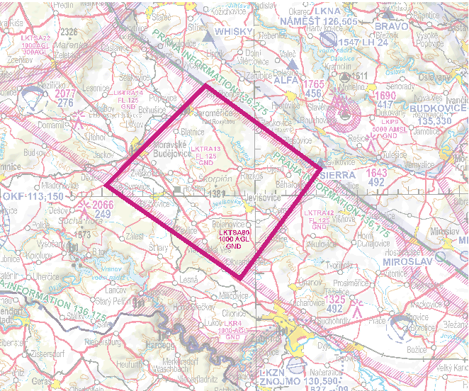
New temporary segregated area LKTSA80  |
07 AUG 25 |
AMDT 9/25 | |
|
49 24 16 N 017 17 48 E |
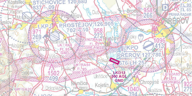
New danger area LKD12  |
07 AUG 25 |
AMDT 9/25 | |
|
ANC ICAO 1:500 000 |
49 25 33 N 017 24 17 E |
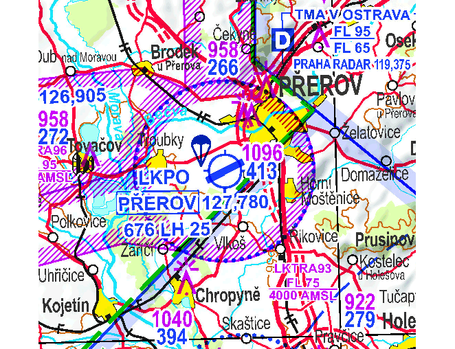
AD LKPO - addition of symbol „Parachute Jumping Site“  |
20 MAR 25 |
AMDT 4/25 |
|
Back side | ||||
|
NIL | ||||