


 Česky
Česky
UAS – Geo zones
Disclamer: changes to the website structure
Over the next few days, changes will be made to the structure of this website. Some sections may be removed or moved.
The aim of these changes is to improve clarity and provide easier access to published data packages and their purpose.
Thank you for your understanding.
Remarks on published data in ED-318 format
Published data in ED-318 format are intended for geoawareness functions in unmanned systems. Due to technical limitations of most target devices, the data has been generalized – the geometry of the boundaries has been simplified so that the file size complies with the limits of the ED-318 format and the limits of unmanned system software. The exact and legally binding boundaries of the geographical zones are available in the .geojson reference files in the table below. The data is published in two ZIP files:
For categories A1/A2
For category A3
Contains all binding layers, including the HOP (densely populated area) layer, which is binding for categories A1/A2. Does not contain the Settled Area layer, which is only intended for category A3.
Contains all mandatory layers, including the Settled Area layer, which is mandatory for category A3. Does not contain the HOP (densely populated area) layer, which is only intended for categories A1/A2.
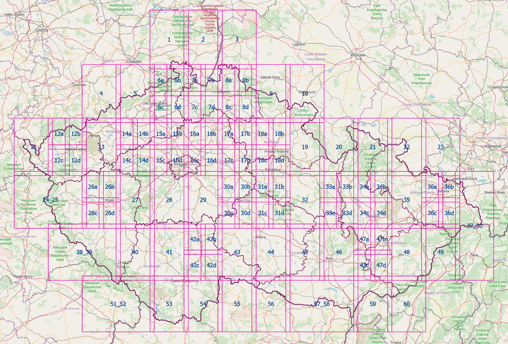
The files are divided into numbered tiles (see image below), with each tile containing an overlap of 2.3 km. The published data serves only as a technical representation for specific purposes and is not intended as a substitute for reference data. For pre-flight preparation and flight planning, we recommend using the DroneMap, which displays the current and accurate zone boundaries. Data is updated regularly in line with AIRAC cycles. Each release is archived and may be further refined based on technological developments.
Overview of numbered tiles in data packages
Actual
| Zone | Description | File | Size | MD5 SUM | Effective from |
|---|---|---|---|---|---|
| LKR311A - Railway Inner Zone – Railway Administration | Area less than 5 m from the centre line of the outer track | LKR311A.json | 88,54 MB | 09e1fb7a2e4c904ca011b1b382d7ee99 | 19. 2. 2026 |
| LKR311B - Railway Outer Zone – Railway Administration | Area from 5 m to 60 m from the centre line of the outer track | LKR311B.json | 171,66 MB | d8f92667347a3e5cf566be1eb7cc05f7 | 19. 2. 2026 |
| LKR311C - Railway Inner Zone – Other Operators | Area less than 5 m from the centre line of the outer track | LKR311C.json | 1,54 MB | 1c8dc103b072e7b82c504a4a1d65cea4 | 19. 2. 2026 |
| LKR311D - Railway Outer Zone – Other Operators | Area from 5 m to 60 m from the centre line of the outer track | LKR311D.json | 2,99 MB | e7ef018040aa488892676664d7c5a5c6 | 19. 2. 2026 |
| LKR312A - Protective zone of electrical substations 110kV+ | Protection Zone of Electrical Substations above 110 kV+ | LKR312A.json | 902,58 kB | 34b5f8350188e9ac3c14aebe6186428b | 19. 2. 2026 |
| LKR312B - VHV lines protection zone 220kV+ | Protection Area of High-Voltage Power Lines (HV) | LKR312B.json | 1,53 MB | 809237c5569c2c707f8006903b2899c9 | 30. 10. 2025 |
| LKR313 - Potable Water Reservoirs | Area of Water Surface at Maximum Backwater Level (Protection Zone I) | LKR313.json | 775,1 kB | 8be840535df6ad0fd5dcd8e7798b55f6 | 30. 10. 2025 |
| LKR314A - CTR and ATZ IFR Outer Zone | Restricted Area from CTR/ATZ IFR Boundary up to Inner Zone Boundary | LKR314A.json | 12,68 kB | 9e27740af22ee183d2f0bb5eb6b2d6e6 | 30. 10. 2025 |
| LKR314B - CTR and ATZ IFR Inner Zone | Restricted Area <1 km from Airport Perimeter and <1 km from RWY CTL (+5 km from THR) | LKR314B.json | 58,16 kB | 897ff1e9737247ecb766ecaccfaca8ea | 30. 10. 2025 |
| LKR314C - CTR LKPR Outer Zone | Restricted Area from CTR LKPR Boundary up to Inner Zone Boundary. | LKR314C.json | 2,45 kB | 115ae7741b46f59fee5177525f5491fb | 30. 10. 2025 |
| LKR314D - CTR LKPR Inner Zone | Circle with Radius 5.5 km from ARP | LKR314D.json | 21,28 kB | 824ba89e2cdd940cf163a2ffe69538ed | 30. 10. 2025 |
| LKR314E - MCTR Outer Zone | Restricted Area from MCTR Boundary up to Inner Zone Boundary | LKR314E.json | 3,29 kB | b303097cbc7aacd92254b7fde765f63e | 30. 10. 2025 |
| LKR314F - MCTR Inner Zone | Restricted Area <2.5 km from RWY CTL (+1.5 km from THR) and <1 km from RWY CTL (+5 km from THR) | LKR314F.json | 4,51 kB | 2ded04ef672de1a92160b1716afb102d | 30. 10. 2025 |
| LKR315A - ATZ | Area around Uncontrolled Aerodromes up to 5500 m from ARP | LKR315A.json | 2,05 MB | bd2d78e3465fd1fd7f3401a197360dc7 | 30. 10. 2025 |
| LKR315B - LS | Area around Sport Flying Facilities up to 1500 m from ARP | LKR315B.json | 246,75 kB | c97449d65241e9cd5acda054b1f825a0 | 7. 4. 2026 |
| LKR315C - HEL | Area around Heliports within 3000–1000 m, 1000–200 m, and <200 m from HRP. | LKR315C.json | 16,25 MB | 04c78765b6b2235057cc6cdf9b33a4c1 | 9. 7. 2026 |
| LKR315D - PIS | Area around Public Interest Sites (Backup Heliports) within 3000–1000 m, 1000–200 m, and <200 m from RP | LKR315D.json | 14,49 MB | 578e6f60b937e0bbd28e9adfdb0c0758 | 30. 10. 2025 |
| LKR316 - Built-up area (Czech Republic) | Build-up Area Category A1 and A2 | LKR316.json | 379,38 MB | a9370f8154ab590fcfd855a53239f3f7 | 30. 10. 2025 |
| LKR317A - Highways and roads for motor vehicles | Restricted Area around Major Road Transport Infrastructure – Motorways and Expressways | LKR317A.json | 6,53 MB | 1cc526f0e4a976b13c64ea2430120d40 | 30. 10. 2025 |
| LKR317B - Class I. roads | Restricted Area around Major Road Transport Infrastructure – Class I. Roads | LKR317B.json | 20,75 MB | 12ff7046afa56dfedaf4add8f99477fd | 30. 10. 2025 |
| LKR317C - Class II. roads | Restricted Area around Major Road Transport Infrastructure – Class II. Roads | LKR317C.json | 57,17 MB | 7340b2cc7da837bb352c0ea84f8c665a | 30. 10. 2025 |
| LKR317D - Class III. roads | Restricted Area around Major Road Transport Infrastructure – Class III. Roads | LKR317D.json | 161,27 MB | 19d28222f13d5195ca44c41c5e8c88a3 | 30. 10. 2025 |
| LKR318A - National parks | Areas with the Highest Level of Nature Protection in the Czech Republic – National Parks. | LKR318A.json | 1,27 MB | 0b683d668d1cab48aefc6be3fdaf0103 | 14. 5. 2026 |
| LKR318B - Small-scale protected areas | Areas with the Highest Level of Nature Protection in the Czech Republic – Small-Scale Protected Areas | LKR318B.json | 15,22 MB | d4009b4ac478883ad58193a5cb805ced | 14. 5. 2026 |
| LKR318C - Protected landscape areas | Areas with the Highest Level of Nature Protection in the Czech Republic – Protected Landscape Areas | LKR318C.json | 64,95 MB | a65e06618edd13ea27dc04ce68918ba8 | 14. 5. 2026 |
| LKR319 - Objects important for state defense | Ensuring the protection of objects important for the defense of the state | LKR319.json | 4,83 MB | cd7862a023670a69a0764b47ba7f85da | 9. 7. 2026 |
| LKR320A - Airspaces | Airspaces Established under §44 of the Civil Aviation Act, Classified as LKP, LKD, TSA, TRA, RMZ, TRA GA a TMA and Restricted Area. | LKR320A.json | 375,73 kB | 1cefacf74b5cd832980ce3ea374c2b5f | 29. 6. 2026 |
| Grids of non-controlled airports | Grid of Restricted Areas in Uncontrolled Airspace. | GRID_ATZ.json | 35,37 MB | a9601478c0216a48a374ba1d04c6aeb2 | 19. 2. 2026 |
| Grids of controlled airports | Grid of Restricted Areas in Controlled Airspace. | GRID_CTR.json | 6,68 MB | ba53df2c5dd956118f588d172dc2d509 | 30. 10. 2025 |
| All files - geojson | Complete Set of All Geographical Zones According to Measures of a General Nature (OOP). | geozones_geojson.zip | 255,6 MB | 4957aee78117be9ecaae71e7b86a1b85 | 9. 7. 2026 |
| ED-318 A1, A2 - tiles | Set of ED-318 format map tiles for UAS category A1, A2 | ed_318_a1_a2_tiles.zip | 34,4 MB | de24db48384a3d8de5742a6ce55aec2d | 9. 7. 2026 |
| ED-318 A1, A2 - all | ED-318 format file for UAS category A1, A2 | ed_318_a1_a2_all.json | 302,39 MB | 3a7e98d0e15ab216299771b12e910299 | 9. 7. 2026 |
Future – effective date 6. 8. 2026
| Zone | Description | File | Size | MD5 SUM | Amendment |
|---|---|---|---|---|---|
| LKR315A - ATZ | Area around Uncontrolled Aerodromes up to 5500 m from ARP | LKR315A.json | 2,05 MB | 5253c17ca14e7d2d4f9a15bf6c639309 | VFR 6 AUG 26 (1) |
| Grids of non-controlled airports | Grid of Restricted Areas in Uncontrolled Airspace. | GRID_ATZ.json | 35,36 MB | cfa0bce20739efe79435d63d740d933c | |
| ED-318 A1, A2 - tiles | Set of ED-318 format map tiles for UAS category A1, A2 | ed_318_a1_a2_tiles.zip | 45,99 MB | d67df314411557e0b4fc6001e9b9de1f | |
| ED-318 A1, A2 - all | ED-318 format file for UAS category A1, A2 | ed_318_a1_a2_all.json | 393,14 MB | 1565980dd0c3f41db9079c5361609d69 |
Future – effective date 6. 9. 2026
| Zone | Description | File | Size | MD5 SUM | Amendment |
|---|---|---|---|---|---|
| LKR320A - Airspaces | Airspaces Established under §44 of the Civil Aviation Act, Classified as LKP, LKD, TSA, TRA, RMZ, TRA GA a TMA and Restricted Area. | LKR320A.json | 399,43 kB | 6e90cfae359cbfb41e75521c09d07b02 | AIP SUP 13/26 |
| ED-318 A1, A2 - tiles | Set of ED-318 format map tiles for UAS category A1, A2 | ed_318_a1_a2_tiles.zip | 46 MB | 7834674898c9001e184bd29abfc60557 | AIP SUP 13/26 |
| ED-318 A1, A2 - all | ED-318 format file for UAS category A1, A2 | ed_318_a1_a2_all.json | 393,18 MB | 19b8e31cbbbc7972a649c40928b11237 | AIP SUP 13/26 |
By using the data sets, you agree to the following terms: Terms of use
You can find more detailed information in the Aeronautical Information Publication AIP and in the VFR manual. The AisView or DronView application can be used for visualization of aeronautical zones on the map.
For error reporting and support please use contactaim@ans.cz